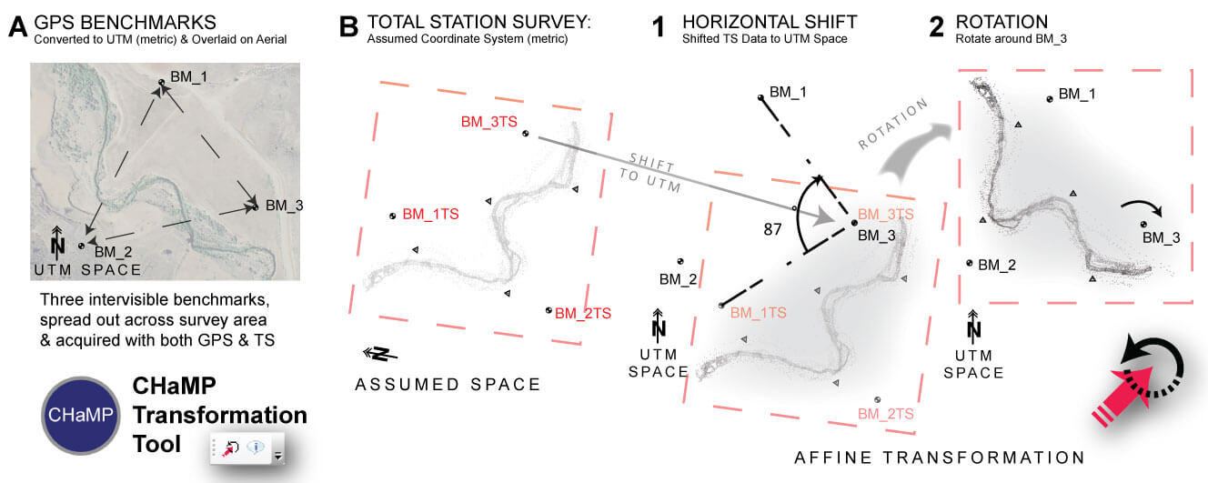
The CTT was developed to support the post-processing workflow for topographic and habitat surveys in the Columbia Habiat Monitoring Program (CHaMP). The tool is an ArcGIS Add-In and when added shows up as a toolbar:
What does it do?
The Ecogemorphology & Topographic Analysis Lab (ET-AL) and the RSGIS Laboratory developed this ArcGIS Add-in for the transformation and projection of CHaMP field survey data (Bouwes et al. 2011) into real world coordinates given hand-held GPS coordinates from just three benchmarks. The CTT will work with any unprojected data in a file geodatabase, and gives you multiple ways to do an afine transformation based on a simple shift and rotation. Although other transformation tools exist in ArcGIS, there is not a simple sequence of geoprocessing tools, which allow you to transform vector data in a manner that preserves the high relative accuracy of a total station survey. See Wheaton et al. (2012) and the ReadMe page for more background.

News! CTT Receives Award for Best Desktop GIS Software

Chris Garrard, who developed the CHaMP Transformation Tool for ET-AL recently presented the tool at the 2012 ESRI International User Conference. She was awarded third place for best Desktop GIS Software Application in the User Software Application Fair.
Funding
Funding for the CTT was provided by the Bonneville Power Administration (BPA Proposal # 2011-006-00 & BPA Project: 2003-017-00 ) and NOAA as part of the Columbia Habitat Monitoring Protocol (CHaMP).

Tool Development
The CHaMP Transformation Tool was developed by Joe Wheaton and Chris Garrard) at Utah State University, with design input from Carol Volk and Kelly Whitehead (South Fork Research). For more information, see http://www.champmonitoring.org.

References
- Bouwes N, Moberg J, Weber N, Bouwes B, Bennett S, Beasley C, Jordan CE, Nelle P, Polino S, Rentmeester S, Semmens B, Volk C, Ward MB and White J. 2011. Scientific Protocol for Salmonid Habitat Survyes within the Columbia Habitat Monitoring Program, Prepared by the Integrated Status and Effectiveness Monitoring Program and published by Terraqua, Inc., Wauconda, WA, 118 pp.
- Wheaton JM, Garrard C, Volk C, Whitehead K and Bouwes N. 2012. A Simple, Interactive GIS Tool for Transforming Assumed Total Station Surveys to Real World Coordinates - The CHaMP Transformation Tool. Submitted to Computers & Geosciences.42: 28-36. DOI: 10.1016/j.cageo.2012.02.003.
